Historic consciousness in the UAE and in the other GCC states goes back only a few centuries, at most; this is how far back most prominent Emirati families can reliably trace their genealogy.

What happened in these lands before the advent of Islam is as alien to the current population, as if it had happened on another continent.
This disconnect, which is the driving force of my research project Searching for Ancient Arabia, was explored in the case of the UAE in this article I wrote:
Archaeology, the past and the present in the UAE
As part of this research project I visited three archaeological sites in Eastern Sharjah Emirate, exemplary for the range of different approaches that can be taken towards cultural heritage: Jebel Buhais, Mleiha and Thuqeibah. I also visited the Sharjah archaeological museum and spoke to a few archaeologists working in the emirate. Taken together these encounters sketch the range of cultural heritage policies in the emirate of Sharjah.
I also visited the site of Hili near Al Ain, and the Al Ain museum, and tried to find the cemetery at Dibba with the graves of, according to legend, ten thousand local Muslims who refused to submit to the authority of the first caliph, Abu Bakr. These experiences were all enriching in their own way, opening new perspectives on my research project ‘Searching for Ancient Arabia’ and raising further questions.
This is the first of two blog posts outlining how the UAE deals with its ancient past.

Eastern Sharjah Emirate
The first three sites lie along the western foothills of the Hajjar Mountains, as they extend from Oman along the Indian Ocean coastline to the peninsula of Musandam. The mountains still catch some rainfall, irrigating the plains to the west (along the eastern coast the mountains drop into the ocean, leaving little space for cultivation). In the past the rainfall, and thus the amount of rain-fed plains, was much higher (in the centuries before the arrival of Islam this area was densely populated; there were even lakes near Mleiha). It was thus a logical place for human settlement, and this is where most of the archaeological findings of the past decades in the Emirates have taken place.
This was evident from a large wall map in the Sharjah Archaeological Museum. Much of the collection on display in that museum comes from this area, providing evidence of advanced cultures in urban settings during the Iron Age (1300 BC to 300 AD), when this area – encompassing the eastern half of the UAE and the northern half of Oman – was called Magan.
Magan is the name given by the Sumerians to ancient Oman, which supplied them in copper and was also an important trading post with the Indus Valley civilizations and ancient Yemen. The name stayed in use until the Achaemenid period, the Persians having an acute strategic and commercial interest in this region just across the Hormuz straits. One can read the fascinating book by the archaeologist D.T. Potts on Ancient Magan here.

Jebel Buhais
Jebel Buhais is known as a mass burial site that was used as early as 5000 BC, but became more frequently used in the late Bronze Age (2500 to 1300 BC), when the population of the area grew as a result of agricultural improvements and trade with Mesopotamia and ancient Persia. Some tombs held the remains of as many as 1000 people. The tombs, their shape and disposition, the way people are buried and what they are buried with are all sources of abundant information for researchers interested in the cultures which succeeded each other in this area. Many of these findings are excellently presented in the Sharjah Museum of Archaeology, and described in papers and articles that can be found in the Emirate’s universities.

To the visitor, however, the site reveals very little. Although it is well indicated with a big sign along the road, all the digs have been recovered with earth and stones. Only a small sign with a number provides clues to the archaeologists, but there is no information for visitors.
We wandered for a while over this mountainous outcrop overlooking the plains of Eastern Sharjah (see a short illustrated description of the site by my research assistant here). It must have been always dry, and therefore a good place to ‘stock’ the remains of human beings of the settlements around it, being neither fit for cultivation or for habitation. The sun was beating down on us and we started using our imagination to discern traces of the past in an otherwise unremarkable landscape. We found for example that the mountain was still used to dispose of animal carcasses, and here and there the disposition of stones in circular patterns seemed to indicate groups of ancient graves.

After climbing to the top of the ridge of the low mountain, thus gaining a view of the other slope of it, we decided to return to the car, uncertain of what we had actually gained from this rather strenuous visit.
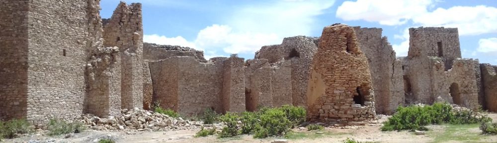
Mleiha
M(i)leiha was a wealthy city from the 3rd century BC to the 2nd century AD, living from metallurgy (the copper mines of Magan, situated in the nearby mountains, were famous in antiquity), agriculture and trade. Amphora from ancient Greece, pottery, weapons and other items from the Middle East and the Eastern Mediterranean were found here. Only part of the big city has been excavated, each dig delivering many interesting results.

Of note are the fort, which stands next to the E55 highway, and of which the lower walls have been restored, clearly indicating the layout to visitors; the burial sites (in which camels and horses used to be interred too), and a large round stone funeral monument from the Umm al Nar period (end of the third millennium BC); but there have been many other prospective digs with promising results by local, French, Belgian and Australian archaeological teams. It is expected that over the years Mleiha will lead to many more discoveries about the period preceding the advent of Islam.

This is probably why the Emirate’s government has decided to create a major visitors center and touristic experience. Currently there’s a rather shabby playground and an empty “heritage village” (Qaryat-al Turathiyya) built around the Bronze Age tomb, set inside a large green park which, presumably because of its rather off-center location, does not seem to attract many visitors. The other Mleiha site ready for visitors is the fort, covered by an immense roof to protect it from the elements. The intention is to open many more of area’s sites to visitors, building structures to accommodate, entertain and instruct them in line with the latest ideas about eco-tourism, sustainable development and community involvement in cultural heritage preservation (read more about it here).
Mleiha is thus the exact opposite of Jebel Buhais. Here nothing is left to the imagination, information is readily available and the visitors experience is carefully channeled. The archaeological remains are neatly reconstructed to child-safety standards. This could be interesting if there was more to see; hopefully the other archaeological excavations, when open to visitors, will make it a more rewarding experience than it is now.
Al Thuqeibah
Named after a very small agricultural settlement located along the dry riverbed entering Al Madam, this was the most difficult site to find. It is currently being excavated by a Spanish archaeological mission – when we were there, however, only Pakistanis were working, the archaeologists coming to dig during field season (in the winter) only.

The excavation team was uncovering gardens and small fields hewn out of the rocky ground, that were irrigated by a falaj bringing fresh water from the nearby mountains. As the Spanish-speaking Pakistani overseer Ayub pointed out to us, the soil and the water irrigating it were retained by rims around them. But instead of building the retaining walls on top of the earth, as is usual, here it seemed the earth had been dug out, revealing beautiful patterns that showed exactly where the trees and wet fields were located; in this way they could be precisely irrigated from the falaj, the water spreading through the connected patches of soil downhill.
The excavations at Al Thuqeibah have just started, including some well-preserved houses. They indicate that in agricultural terms, too, local society was more developed than previously imagined. For visitors like us, this is the most rewarding kind of site. A lot is left to the imagination, but the excavations reveal sufficient details and are aesthetically rich enough to excite that imagination. The presence of an excavation team willing to talk about its work adds a lot to the experience.
Jebel Buhais, Mleiha and Al Thuqeibah thus exemplify the three stages of archaeological site development a visitor can experience: underdevelopment, overdevelopment and ‘in’ development. One could also take them to symbolize the different levels of commitment to archaeology in the Emirate of Sharjah, between neglect, superficial touristic development and true research. Of course this is not only true of Sharjah, as the visitor could probably find this range in any country’s cultural heritage policies.
Dibba
We drove along the Indian ocean coast from Fujairah through Khor Fakkan to Dibba, on the border of the Omani exclave of Musandam. We wanted to find the cemetery where, according to the legend, ten thousand apostates were buried. Indeed, after the death of the Prophet Muhammad part of the population rebelled against caliph Abu Bakr, who promptly sent troops to quell the rebellion. According to the most commonly followed historic account (by early Muslim historian Al Tabari), ten thousand locals perished in the confrontation.
This historic episode shines a rare light on what was a more tumultuous acceptance of political Islam in the Arabian peninsula than is usually thought. The main narrative of this process is simple: before the death of the prophet the whole Arabian peninsula had embraced Islam, and that’s it. Mention is sometimes made of the Kharijites and the Zaydis as breakaway factions of mainstream Sunni orthodoxy on the peninsula; they survive today in Oman (the Ibadis) and Yemen (Zaydis). But in fact caliph Abu Bakr had to fight wars against those who didn’t accept his rule in all parts of the Arabian peninsula (the so-called Ridda Wars) during the first years of his caliphate.
What connected all these revolts was a rejection of the principle of succession by designation. The Ibadis and Zaydis still believe that their religious leader must be chosen by the believers in the community and prove himself worthy of the function. This strokes with the traditional mechanism to select a leader among Arab tribes – dynastic succession never sat well with them until the 18th century. This must obviously have happened with the people of Dibba: when the prophet Muhammad died they saw no reason to blindly accept his successor Abu Bakr. They paid for it dearly. If indeed 10.000 people died, this cannot be the result of the battlefield, but must imply a wholesale massacre of the local population, which, archaeological evidence ascertains, was much more important during the time of the Prophet than in later centuries.
When visiting Dibba we had no mobile internet coverage, so we relied on local inhabitants to guide us to the cemetery; later it turned out we had visited (and abundantly photographed) the wrong one (a picture of the presumably correct cemetery can be found here). Curiously, despite the historic significance of the event and the rather large landmark it left, few local people seemed aware of its location – probably the result of a history suppressed because deemed shameful.
Hili Archaeological Park
The Bronze Age settlement (ca 2000 BC) of Hili lies just outside Al Ain. It is a UNESCO world heritage site, composed of a large circular stone collective tomb, typical of the Umm al Nar period (similar to the one in Mleiha), the foundations of several buildings – including what appears to have been a defensive fortress – and a falaj (underground water channel). A pleasurable green park has been built around the stone tomb and the foundations of two other bronze age buildings, but most of the site is outside that park, off-limits to casual visitors, straddling the Omani border.
Even more so than the facilities built around Mleiha, Hili archaeological park leaves little to the visitor’s imagination. As I was strolling among the many tourists visiting the park, I was struck by how this presentation of the past is more representative of the current epoch than the past itself (this opinion was shared by the way, by several other visitors). I started photographing details of the current tourist infrastructure as if I were performing some kind of future archaeology, imagining that these facilities will be excavated in 2000 years and taken as exemplary of the level of development of Al Ain, its economy, the beliefs of the people etc in 2000 AD.

Based on my findings a future archaeologist could conclude that the area was luxuriantly green and that the population of Hili was mostly white, generally so obese they needed to be motorized, and that they worshipped ancient stone structures.
This reminded me of a conversation I had with Ruth Impey about the dating techniques used by archaeologists. She a specialist in Julfar pottery, which was produced for many consecutive centuries in Ras al Khaimah Emirate, and widely exported throughout the region; the stylistic differences in the found pottery from Julfar is often used to date an archaeological site. These stylistic differences can be quite minimal, like a curved lip of a jar versus a straight one indicating a difference of two centuries.
Ruth is a potter herself, and has embarked on a project (also supported by FIND) to revive Julfar pottery production, although the last local potters, who knew how to assemble the clay and what to fire the kilns with, died a generation ago. She admitted that the dating technique based on Julfar pottery is not foolproof, as it assumes that all potters will adopt the same stylistic differences more or less simultaneously, and that none of them will produce pottery in a ‘retro’ style practiced by his ancestors.
This is probably why I feel uncomfortable with the definite presentation at archaeological sites such as Hili or Mleiha: because they assume that all the information collected through uncertain archaeological methods is correct, while it is quite likely that in the future, new information will invalidate many of these assumptions. Archaeologists and scholars themselves are usually not so adamant about the accuracy of their interpretations; it is when their findings are translated into easily digestible ‘educational tools’ or ‘visitors guides’ that assumptions are converted into affirmations.
Archaeological presentations in the museums of Al Ain and Sharjah
The translation of uncertain and often contradictory findings by archaeologists into a historic narrative takes place most clearly in the museum. There is a big difference, in this regard, between the Al Ain National Museum , where many of the findings of Hili are presented, and theSharjah Archaeology Museum.
An obvious difference is in the presentation: Al Ain is a somewhat stuffy museum with linear displays, with often missing or insufficient information about the pieces presented. The Sharjah museum, in contrast, gives a contemporary, multi-media and less linear display and offers quite a lot of information about the displayed artifacts. A new national museum is being planned for Al Ain which will certainly conform to the latest practice in museum displays and to the subtleties of current national discourses in the UAE.

A more subtle difference is the objective of the museum: where the National Museum of Al Ain seeks to present a national narrative, including ethnographic artifacts and photographs of the pre-oil period (fig 9), the museum in Sharjah seems geared towards the display of archaeological findings. In the first case, contradictions can be problematic (because they weaken the narrative), while in the second case, they can easily be justified (as elements of multiple storylines which are still being developed).
As source of artistic inspiration, the Archaeological Museum of Sharjah is thus much richer – and definitely one of the better museums in the UAE – leading to many possible links between the past and the present, while the National Museum of Al Ain seemingly forecloses such multiple interpretations.
My visits made clear that the person wanting to understand the UAE’s ancient past is confronted with incomplete and often contradictory impressions, between sheer lack of information, occasionally willful negligence and dubious appropriation of the country’s cultural heritage. In my next blog I hope to elucidate how the UAE’s efforts to consolidate its national identity influence the relation to the past.
Illustrations and captions
Introduction: Photograph of Abu Dhabi in the 1950s; please supply the name of the photographer if known (this photograph was on display in the Al Ain National Museum without any information about it)
Fig 1 Map of the sites I visited in the Emirate of Sharjah.
Fig 2 Ancient mass graves of Jebel Buhais, scale models photographed at the Sharjah Museum of Archaeology. Photos by author.
Fig 3 Marker on the site of Jebel Buhais indicating location of an archaeological find. Photo by author.
Fig 4 Bones from recently killed animals litter the Jebel Buhais site. Photo by author.
Fig 5 The fort of Mleiha such as it greets the visitors. Photo by author.
Fig 6 The ‘Umm al Nar’ tomb of Mleiha, within the visitors’ park. Photo by author.
Fig 7 Irrigation channels carved out of the soft rocky ground at Al Thuqeibah. Photo by author.
Fig 8 Collage of contemporary culture for future archaeology at Hili Park. Photos by author
Fig 9 Diplomatic gifts to the UAE from other Arab countries displayed at the Al Ain National Museum. Photo by author.